Autonomy starts with navigation, not independent judgement
When people say a drone is autonomous, they may mean that it can hold a position, follow GPS waypoints or complete a pre-planned route with limited manual input. That is very different from a machine independently deciding what mission to perform.
A modern flight stack can automate many low-level tasks: estimating position, maintaining altitude, following waypoints, adjusting attitude and responding to obstacles. AI can add perception and decision-making capabilities on top of that.
The important distinction is between autonomous navigation and fully independent decision-making. A drone may be able to choose how to steer around a tree without being able to decide whether it should enter a particular property, change the mission objective or operate without human oversight.
Computer vision gives the drone a view of its surroundings
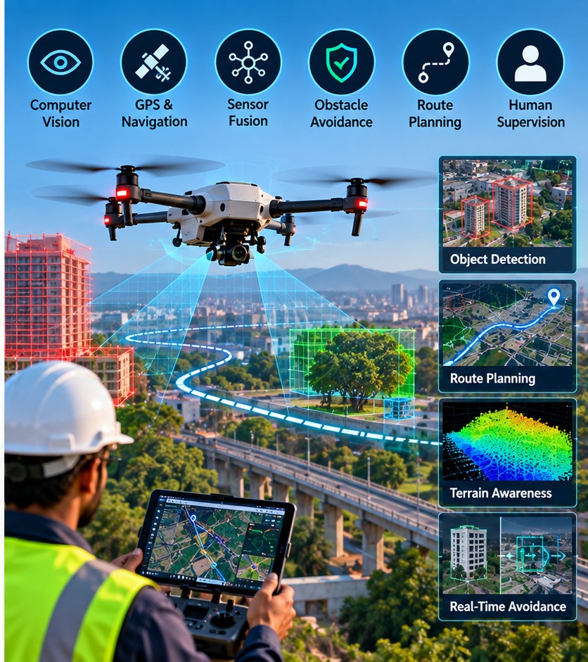
Computer vision means using cameras and software to extract useful information from images or video. For drones, that can include recognising obstacles, estimating movement, identifying landing areas or helping estimate position when GPS is unavailable or unreliable.
PX4 documents several vision-based methods. Optical flow can estimate two-dimensional movement using a downward-facing camera and distance sensor, while Visual Inertial Odometry combines camera information with an inertial measurement unit to estimate motion and position.
This is useful because GPS is not perfect everywhere. Buildings, trees, indoor environments or interference can make satellite positioning less reliable. Vision gives the flight system another source of information, although it also has limitations such as darkness, glare, rain, texture-poor surfaces and computational requirements.
Sensor fusion: combining imperfect measurements
A drone rarely relies on one sensor for navigation. GPS provides global position, an IMU measures acceleration and rotation, a barometer helps estimate altitude, and range sensors or cameras can provide additional information.
Sensor fusion combines these measurements into an estimate of the aircraft's state. PX4's navigation filter uses an Extended Kalman Filter, or EKF, to process sensor measurements and estimate position, velocity, orientation and sensor biases.
The simple idea is similar to checking several instruments instead of trusting one. If GPS briefly becomes noisy but the IMU and other measurements remain consistent, the estimator can maintain a useful navigation estimate. If measurements disagree too much, the system can flag uncertainty rather than pretending it knows exactly where it is.
Obstacle avoidance and route planning
Once a drone can estimate its position and perceive obstacles, software can plan how to move through the environment. Obstacle avoidance systems can modify a planned route to go around an object rather than simply following a fixed line.
PX4's documentation describes obstacle avoidance as a companion-computer function that can generate a route around obstacles during supported automatic missions. Research systems also combine cameras, radar or other sensors with state estimation and path-planning algorithms.
But avoidance is not magic. A drone has limited speed, computing power, sensor range and braking distance. A thin wire, reflective surface, moving person or rapidly changing environment can create a difficult perception problem. A safe autonomous system therefore needs conservative limits and a way for the human operator to intervene.
Why human supervision still matters
The more autonomous a drone becomes, the more important it is to define what the automation is actually allowed to do. A route-following system may handle navigation while the operator remains responsible for the mission, surrounding people, airspace and abnormal situations.
Human supervision is particularly important when the environment is unpredictable. If a sensor fails, weather changes, the aircraft encounters an unexpected obstacle or the mission needs to change, a person may need to take control or stop the operation.
That is why autonomy should be understood as a layered system. GPS and sensors estimate where the drone is. Computer vision helps it understand nearby objects. Planning software chooses a path within defined constraints. The flight controller executes that path. The human remains the safety layer that can supervise, intervene and define the mission.
AI can therefore make drones more capable without making them independent agents. The practical goal is often not to remove the pilot, but to let the pilot supervise more complex missions with fewer repetitive manual inputs.