Can a Drone Navigate When GPS Disappears?
Inside GPS-denied robotics: how visual-inertial odometry, LIDAR SLAM, and event cameras let drones navigate through pitch-black tunnels, dense forests, and jammed airspace.
Published: Oct 07, 2026
5 mins read
👁️ 11 Unique Views
Imagine flying a drone deep inside a collapsed concrete building after an earthquake, or high above a dense forest canopy where radio interference cuts off all satellite communications. For standard commercial drones, losing Global Positioning System (GPS) signals is catastrophic. Without satellite coordinates to correct position drift, onboard flight controllers become blind, causing the drone to drift uncontrollably into walls or tumble out of the sky. But how do cutting-edge autonomous drones navigate pitch-black mines, steel pipes, and jammed airspace completely disconnected from GPS?
The Fundamental Vulnerability of Satellite Positioning
To understand why GPS-denied navigation is so difficult, consider how satellite positioning works. GPS receivers rely on extremely weak microwave signals broadcast by satellites orbiting 20,000 kilometers above Earth. These signals cannot penetrate solid structures like concrete roofs, metal shipping containers, or heavy underground rock.
Furthermore, inexpensive radio frequency jammers can easily overwhelm satellite signals across several square miles (Scaramuzza et al., 2024). For autonomous robots operating in search-and-rescue, underground mining, or defense missions, depending on GPS represents a dangerous single point of failure.
Visual-Inertial Odometry: Turning Onboard Cameras into Digital Eyes
To replace satellites, roboticists at the University of Zurich's Robotics and Perception Group (RPG), led by Davide Scaramuzza, developed Visual-Inertial Odometry (VIO). VIO fuses high-speed camera footage with precise data from an onboard Inertial Measurement Unit (IMU)—the same micro-sensors that track acceleration and rotation in smartphones.
As the drone moves, VIO algorithms identify hundreds of high-contrast visual features in the environment—such as corners of bricks, speckles of gravel, or cracks in a wall—and track their movements frame by frame. By matching these visual movements with IMU acceleration data 100 times per second, the drone calculates its exact velocity, direction, and 3D position in real time without needing outside signals.
Breakthrough with Event Cameras: Flying in Total Darkness at High Speed
Standard cameras fail when a drone flies rapidly past bright lights or into pitch-black tunnels because frames become motion-blurred or dark. To solve this, researchers at Zurich RPG introduced event-based cameras (Scaramuzza et al., 2024). Unlike traditional cameras that capture full rectangular images 30 times a second, event cameras contain smart pixels that operate independently, firing digital pulses only when local light intensity changes.
In real-world flight trials, drones equipped with event cameras navigated unmapped obstacles at speeds exceeding 40 kilometers per hour in environments with extreme lighting changes, maintaining positional drift below 0.5 percent over 1-kilometer flight trajectories (Scaramuzza et al., 2024), proving that visual navigation can match GPS accuracy even in demanding conditions.
LIDAR SLAM: Mapping Subterranean Caverns in 3D
While cameras work well in lit environments, deep underground caverns contain zero ambient light. Research teams from Carnegie Mellon University (Scherer et al., 2024) and MIT's Aerospace Controls Lab (How et al., 2024) addressed this during the DARPA Subterranean Challenge using LIDAR SLAM (Simultaneous Localization and Mapping).
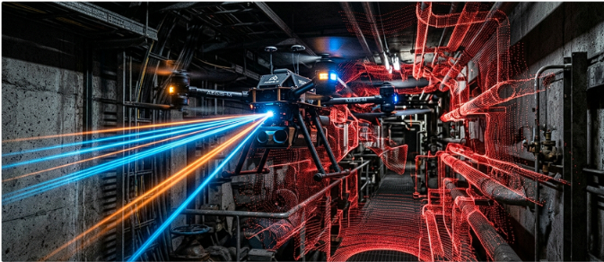
By mounting lightweight spinning lasers on quadcopters, the drones cast hundreds of thousands of invisible laser pulses per second in every direction. The reflected light builds a dense 3D point cloud map of surrounding walls, pipes, and obstacles. The drone simultaneously uses this point cloud to track its position while planning flight paths through unmapped terrain, completely independent of human guidance or satellite links.
Bio-Inspired Navigation: Learning from Ants and Honeybees
Taking inspiration from nature, researchers at CNRS and ETH Zurich (Dupeyroux et al., 2023) developed polarized light navigation modeled after desert ants. Desert ants navigate vast distances across featureless dunes by reading patterns of polarized sunlight in the sky. By installing polarized skylight sensors on micro-drones, researchers enabled lightweight UAVs to maintain accurate directional headings even when magnetic compasses fail near heavy iron structures.
Real-World Limitations and Remaining Engineering Hurdles
Despite these advances, GPS-denied navigation faces clear physical constraints. Dense smoke, thick dust, and heavy fog blind visual cameras and scatter LiDAR laser beams. Additionally, processing high-resolution visual and point cloud data in real time consumes significant computing power, reducing small drone flight times from 30 minutes to around 15 minutes.